 Institute of Transportation Studies and Department of City and Regional PLanning doctoral sudent Marcel Moran recently published Drawing the map: The creation and regulation of geographic constraints on shared bikes and e-scooters in San Francisco, CA in the Journal of Transport and Land Use: http://jtlu.org/index.php/jtlu/article/view/1816
ABSTRACT
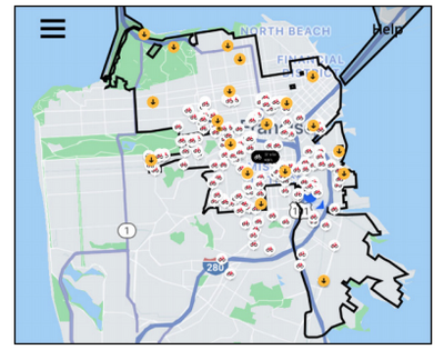
Absrtact: A prominent question in transportation planning is how cities should regulate emerging modes, such as shared bikes and e-scooters. This pertains to a range of attributes, including pricing, use of the public right of way, number of vehicles in a fleet, and vehicle speeds. However, less attention has been paid to the way private operators spatially constrain access to their fleets, such as via the use of virtual geographic boundaries (hereafter “geofences”), or how municipalities have regulated these features. San Francisco, given it is home to a number of these schemes, presents a compelling case for studying geofences, and how regulators have sought to influence them to further public policy goals, including spatial equity. This study analyzes each bike and e-scooter geofence in San Francisco longitudinally from 2017 to 2019 via manual digitization of all geofences. This reveals high levels of overlap in the city’s dense northeast quadrant, with limited to no coverage in western neighborhoods. Each operator’s geofence expanded over this period, filling in gaps in the northeast quadrant and expanding outward in each direction. Review of permit guidelines and applications submitted by operators indicate that San Francisco’s regulations for geofences have been limited and inconsistent, which may have contributed to the concentration of services in one section of the city, as well as disconnected geofence “islands.” Together, these observations demonstrate that if broad geofence coverage (i.e., spatial equity) is an explicit municipal goal, such an aim must prominently feature into the regulatory process. This is particularly important given that operators, if left with freedom over geofence design, are likely to emphasize only a city’s densest areas, especially if tight caps are set on the allowed number of vehicles. Finally, this case also exemplifies that geofences are not drawn in a vacuum but instead relate to other permit conditions as well as pressure from community organizations.
